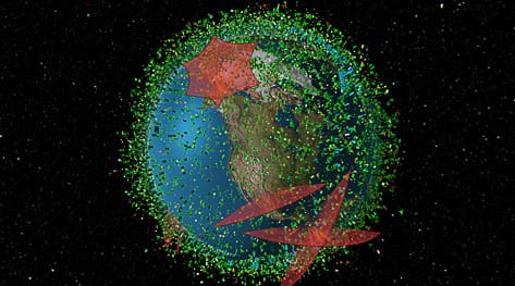
Interactive Visualization of Satellites and Space Debris around Earth
LeoLabs, headquartered in Menlo Park, California, was founded in 2016. They have constructed, and continue to build, a global network of ground-based, phased array radars to track the hundreds of functioning satellites, dead spacecraft, spent rocket bodies, and trash in orbit around the Earth. Not only is their radar technology cutting-edge, but they have also created a magnificent, if not a bit alarming, computerized picture of space traffic that is open to the public.
The visualization shown here is very amazing. The Company, whose founders include astronaut Edward Lu, got its start in an unusual way. The creators’ first work, which arose from high-level research at SRI, was not even remotely related to satellites and space debris.
“The original science was around ionospheric research,” Alan DeClerck, VP of Business Development and Strategy, remembers. The first radar array, built-in Alaska, was designed to investigate the behavior of charged particles in the solar wind as they interact with the Earth’s magnetic field. This contact may interfere with satellites and ground-based electrical equipment, and it is the source of the stunning aurora borealis.


